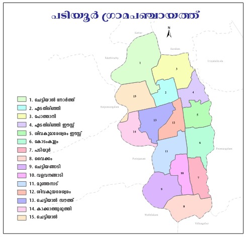

Padiyur panchayath Geography and Map
Padiyoor Grama Panchayat – Geography and Map
Padiyoor Grama Panchayat is a Grama Panchayat situated in Vellangallur Block of Thrissur District, Kerala. Edathirinji and Padiyoor are the major areas within the Panchayat.
Geographical Location
- Padiyoor is situated in the south-eastern part of Thrissur District, in central Kerala.
- It comes under Vellangallur Block Panchayat.
- The area is predominantly a low-lying plain with an average elevation above sea level.
- The surrounding Panchayats and villages have a predominantly rural character, with agriculture and trade being important economic activities.
Topography
- The area is predominantly flat.
- Small hillocks and low-lying paddy fields are found in some areas.
- The soil mainly consists of laterite (red soil) and alluvial soil.
- A considerable portion of the area is fertile and suitable for agriculture.
Water Resources
- Small streams and ponds constitute important water resources of the area.
- Agriculture is largely dependent on rainfall.
- Wells and groundwater are used for drinking water purposes.
Climate
- The area has a tropical monsoon climate.
- The south-west monsoon provides rainfall from June to September.
- The north-east monsoon also contributes rainfall during October–November.
- Summer is generally hot and humid.
Vegetation and Agriculture
- Coconut, paddy, banana, rubber and other crops are commonly cultivated.
- Mixed farming around residential areas is widespread.
- Although paddy fields were more extensive in the past, some areas have now been converted into residential and other developed land.
Transportation and Connectivity
- The Panchayat is connected by road to Thrissur, Irinjalakuda and other nearby towns.
- Rural roads and major roads provide transportation facilities.
- The nearest railway station is in the Irinjalakuda area.
Settlement Characteristics
- The area has a predominantly rural settlement pattern with moderate population density.
- It is one of the areas with a relatively high level of literacy and educational attainment.
Boundaries of Padiyoor Grama Panchayat
Padiyoor Grama Panchayat is part of Vellangallur Block Panchayat. The approximate boundaries of the Panchayat are:
- North – Puthenchira Grama Panchayat
- South – Kattoor Grama Panchayat / Irinjalakuda region
- East – Vellangallur Grama Panchayat
- West – Rural areas towards the Kodungallur region through the Edathirinji area
The Panchayat mainly consists of flat terrain comprising paddy fields, residential areas, and small agricultural holdings.
Ward-wise Information
Padiyoor Grama Panchayat has a total of 14 wards.
The major ward/locality names generally include:
- Padiyoor Centre
- Edathirinji
- Pallippuram area
- Paddy field areas
- Localities with names reflecting eastern/western divisions
The official ward map of the Panchayat is generally available through the Election Commission or K-SMART Ward Map system.
Digital Map of the Panchayat
OpenData Kerala Panchayat Map
Ward GIS Data / Map Reference
Wikimedia Panchayat Boundary Map
Rivers, Streams and Water Resources
Although no major river flows through Padiyoor, the following water resources are important to the local geography:
- Seasonal streams
- Paddy-field canals
- Ponds
- Wells
- Small natural drainage channels
The area has paddy fields with good water-retention capacity and therefore supports agriculture that is largely dependent on rainfall.
Important water-related features include:
- Water channels passing through paddy fields
- Streams connecting the Puthenchira–Padiyoor region
- Groundwater-based drinking water systems
During the monsoon season, some low-lying areas may experience waterlogging.
Population Information
Panchayat-level Information
- Population: Approximately 17,000–18,000
- Number of Wards: 14
- Households: Approximately 4,000+
- Main Language: Malayalam
- Major Occupations:
- Agriculture
- Small-scale trade
- Gulf migration/employment
- Service sector
Census Information of Padiyoor Village (2011)
Padiyoor
- Total Population: 8,823
- Males: 4,115
- Females: 4,708
Geographical Features
- Low-lying plain terrain
- Paddy fields suitable for rice cultivation
- Laterite and alluvial soil
- Rain-fed agricultural area
- Well-developed rural road network
- Strong economic connections with the Irinjalakuda–Kodungallur region